Alaska: Earthquakes and Climate
In Alaska, earthquakes are very common, having an average of 1,000 earthquakes per month. The state experiences more earthquakes than anywhere else in the United States. Earthquakes often happen in Alaska because of the subarctic climate and stress caused by the movements of tectonic plates that make up Earth’s outer shell. On March 27, 1964, Alaska’s residents experienced what is now known as the “ Great Alaskan Earthquake,” the earthquake spread 25 kilometres across Anchorage for about five minutes reaching a magnitude of 9.2 on the Richter Scale. This earthquake caused 139 casualties and $311 million worth of damage to the city of Anchorage. Large earthquakes that occur in subduction zones like this are called “Megathrust.”
Although another US state doesn’t border Alaska, Alaska has more ocean coastline than any other in the United States. Yukon and British Columbia, Canada border the state. The entire state of Alaska is 570,380 square miles making it the largest of the US states. Despite being known for arctic weather conditions Alaska’s temperature can reach a high of 90°F and an extreme low of -50°F during the winter. Alaska is cold because the state is north of the Arctic Circle. The Arctic Circle is the imaginary circle around the earth, parallel to the equator it marks the northernmost point where the sun will appear above the horizon on the winter solstice. The winter solstice or midwinter is a phenomenon that characterizes the shortest period of daylight and the longest night of the year. The extreme cold in Alaska is due to the long winters and very short summers.
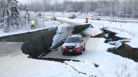
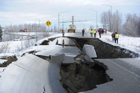
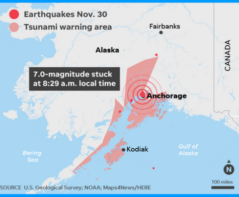
On November 30, 2018, the state of Alaska experienced another megathrust earthquake in Anchorage. This earthquake is the second most massive earthquake in Alaska since the “ Great Alaskan Earthquake” in 1964. The quake struck in the northern part of Anchorage. The damages from the earthquake are still being assessed, but what sticks out most is the ripples and cracks in the roads. Many large structures are still intact, but economic damages for residents are just dreadful. This recent earthquake was a 7.0 on the Richter Scale.
When taking everything into account, Alaska has frequent earthquakes due to the subarctic climate and how close it is to the Arctic Circle. Alaska has had numerous earthquakes because of the geography. Alaska’s most historic quake had a magnitude of 9.2 on the Richter Scale and is the most powerful recorded in US history.

A future designing fashion artist named Marques Stinson was born on February 17, 2002. Marques Stinson plans to study fashion design, styling, and photography...